Getting Around
Getting here and around Downtown Pittsburgh is easier than ever
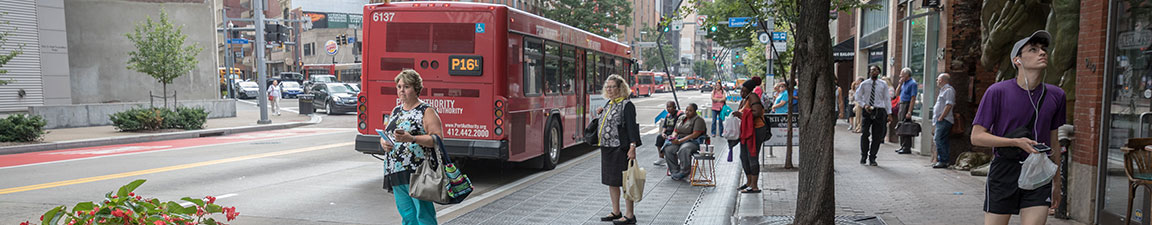
With more than 80 bus and light rail routes serving Downtown daily, relaxing while you let someone else do the driving into town makes commuting a breeze. Downtown is the most walkable neighborhood in Pittsburgh, whether you’re a long-time yinzer or new to the city. Plus, biking, carsharing, and parking are all available and easy to do. Explore more below.
Walking | Biking | Bike Share | Public Transit | Inclines | Rail |Paratransit | Parking | Driving |Tools & Resources
Walking
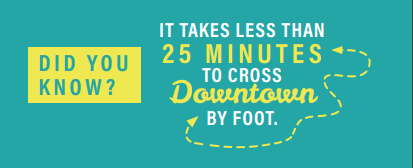
Did you know you can walk from one end of Downtown to the other in 25 minutes or less? Getting to major destinations like sports stadiums, museums, restaurants, and more is accomplished easily on foot. Enjoy the Three Rivers Heritage Trail system for 24 miles of riverfront trails providing access to city neighborhoods, business districts, and local attractions, and cross both the Fort Pitt and Fort Duquesne Bridges with dedicated pedestrian walkways.
Biking
Explore Downtown using dedicated and protected bike lanes throughout the neighborhood. Use the new Mon Wharf Switchback Ramp to effortlessly bike from Point State Park to Smithfield Street, the Three Rivers Heritage Trail, and beyond.
Learn more about biking in Pittsburgh, including how-to videos, maps, tips and tricks, and more at BikePGH.org.
POGOH Bike Share
POGOH is Pittsburgh’s public bike-sharing system and as of May 2022, the system has been revamped and now includes new stations, equipment, and services. Rides start at $3.50 for 30 minute rides on standard bikes and $5.00 for 30 minute rides on e-pedal assist bikes. Learn more and check out the updated system map.
Public Transit
Take a break from the car and don’t worry about the stress of traffic: hop on a Pittsburgh Regional Transit (PRT) bus or light rail train for easy travel into and out of Downtown seven days a week. One-way fares on light rail and buses are $2.75 for both Connectcard and cash users; children up to age 5 ride free with a fare-paying adult. Plan your public transit trip.
The Light Rail system connects the North Shore and Downtown Pittsburgh to the South Hills neighborhoods, including stops nearby Heinz Field, PNC Park, and Rivers Casino. Travel around quickly in the light rail free fare zone with unlimited free travel between the First Side and North Shore stops.
PRT and other bus services connect Downtown to neighborhoods and destinations throughout the region. Bus service to the airport is available on the 28X – Airport Flyer, with a limited number of stops between Downtown and Pittsburgh International Airport.
Heading to the East End? A dedicated bus-only road provides fast travel between Downtown and the East End communities, including Shadyside, East Liberty, Wilkinsburg, and Swissvale.
Make your transit ride even smoother with a ConnectCard. Available for purchase at the Downtown Service Station and Downtown light rail stations, this refillable card acts like cash and can store weekly, monthly, and annual passes. Transfers are free within 3 hours using a ConnectCard.
Mobile payment is also available for all PRT trips. Just download the Transit App and use your smartphone to purchase fares on the go.
Pittsburgh’s Inclines
Historic and offering breathtaking views of Pittsburgh’s iconic skyline, the Monongahela Incline and Duquesne Incline are both parts of the city’s public transit system and provide easy access to and from the top of Mt. Washington. Trips run approximately every 15 minutes.
Both inclines accept the PRT ConnectCard. For fares and more information, click here.
Monday – Saturday: 5:30 a.m. – 12:45 a.m.
Sundays & holidays: 8:45 a.m. – midnight
Payment is accepted at the upper station.
Monday – Saturday: 5:30 a.m. – 12:45 a.m.
Sundays & holidays: 7:00 a.m. – 12:45 a.m.
Payment is accepted at the lower station.
Passenger Rail
The Pennsylvanian and the Capitol Limited have daily trips through Downtown, offering connections to national destinations including Harrisburg, Philadelphia, Chicago, Washington, D.C., and New York City. Learn more.
Paratransit
ACCESS is a paratransit service that provides door-to-door, advanced reservation transportation, primarily serving people with disabilities, human service agencies, and people aged 65 and over. Reserve a ride by calling (412) 562-5353 or Relay 711.
Parking
Did you know that anywhere you are in Downtown, you’re only a five-minute walk from a parking garage? When you do have to drive, check ParkPGH.org for the real-time status of parking garages before you arrive.
On-street, metered parking is available throughout the neighborhood, but be sure to check all posted signage for special event closures, valets, and other restrictions. On-street parking in permitted areas is free after 6:00 p.m. Monday – Saturday and all-day on Sundays and major holidays.
Learn more about parking resources in Downtown.
Driving
Follow these recommended routes to get in and out of Downtown, and stay up-to-date with construction on our Construction Updates page.
Tools & Resources
Downtown Made Easy Guide
Download and save this free map of Downtown Pittsburgh, featuring parks, bicycle parking, the light rail free fare zone, and more.
Looking for a physical map? Request free physical copies for your home or place of work by sending us an email.
Note: If you’re outside the Golden Triangle and are requesting more than 50 guides, please arrange to pick them up at our office. We can mail them to you, however, there will be a fee associated with the mailing.
Zipcar
More and more Pittsburghers are choosing to live without a car, but for those times when having a car is needed, Zipcar Pittsburgh is there. Cars, trucks, and vans are available to rent by the hour or the day throughout Downtown Pittsburgh, with special rates for college students. Zipcar.com/Pittsburgh
Uber, Lyft, & Z-Trip
Catch easy, affordable, and reliable rides within minutes using Uber, Lyft, and Z-Trip services throughout Downtown and the City of Pittsburgh.
Tools We Like
Simplify your daily commute and make getting around even easier. Here are some of our team’s favorite apps and tools:
- Transit App: get real-time information and route planning that combines public transportation, ride-hailing, bike share, and car share (Smartphone App)
- Google Maps: plan your journey and map out detours, whether by foot, bike, car, or public transit (Smartphone App/Web)
- CommuteInfo: find info on how to schedule your daily commute, including regional transit, vanpooling, carpooling, biking, and park-n-ride facilities (Web)
- ParkPGH: plan ahead with real-time availability info for Greater Downtown Pittsburgh garages (Smartphone App/Web/Text/Call)
Note: the tools listed above are third-party products and services that are helpful in getting around Downtown, but are not administered by the Pittsburgh Downtown Partnership.
DOWNTOWN DIRECTORY
About PDP

Join Our Mailing List
Contact Us
412-566-4190
Email Us
Pittsburgh Downtown Partnership
The Bank Tower
307 Fourth Avenue – Floor 2
Pittsburgh, PA 15222